
Michigan Waterfall Road Trip: US-2 in the Western Upper Peninsula
Michigan’s Upper Peninsula is home to more than 300 waterfalls. Each year thousands of visitors check out the large cascades at Tahquamenon Falls State Park, Pictured Rocks National Lakeshore, the Marquette area and more, but that’s hardly all that our state has to offer. The Western U.P. is home to some of the state’s most spectacular waterfalls, most of which are relatively easy to access. This Michigan waterfall road trip follows US-2 from Rapid River in Delta County for roughly 330 miles to the Michigan/Wisconsin border. Along the way, we’ll provide directions to 21 different waterfalls. Some of these falls can be seen from the road or parking areas, others require hikes of a mile or less. This route would work great as a day trip or could easily be stretched to fill a couple days – with the exception of a longer drive between Escanaba and Piers Gorge most of the waterfalls are located within a half hour or less of each other.
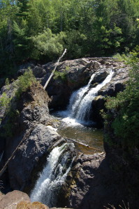
Haymeadow Falls – We start things off just north of Rapid River in the Hiawatha National Forest, where a small, unique cascade is reached after a hike of a half mile. A well-maintained, well-worn trail begins at a small campground. Haymeadow Creek, known for good trout fishing, makes several staircase drops of a few feet. A bridge crosses the river near Haymeadow Falls and allows for views from both sides. From US-2, follow the national forest signs on CR-509, taking the left fork after a half mile then continuing for 8.5 miles to the campground.
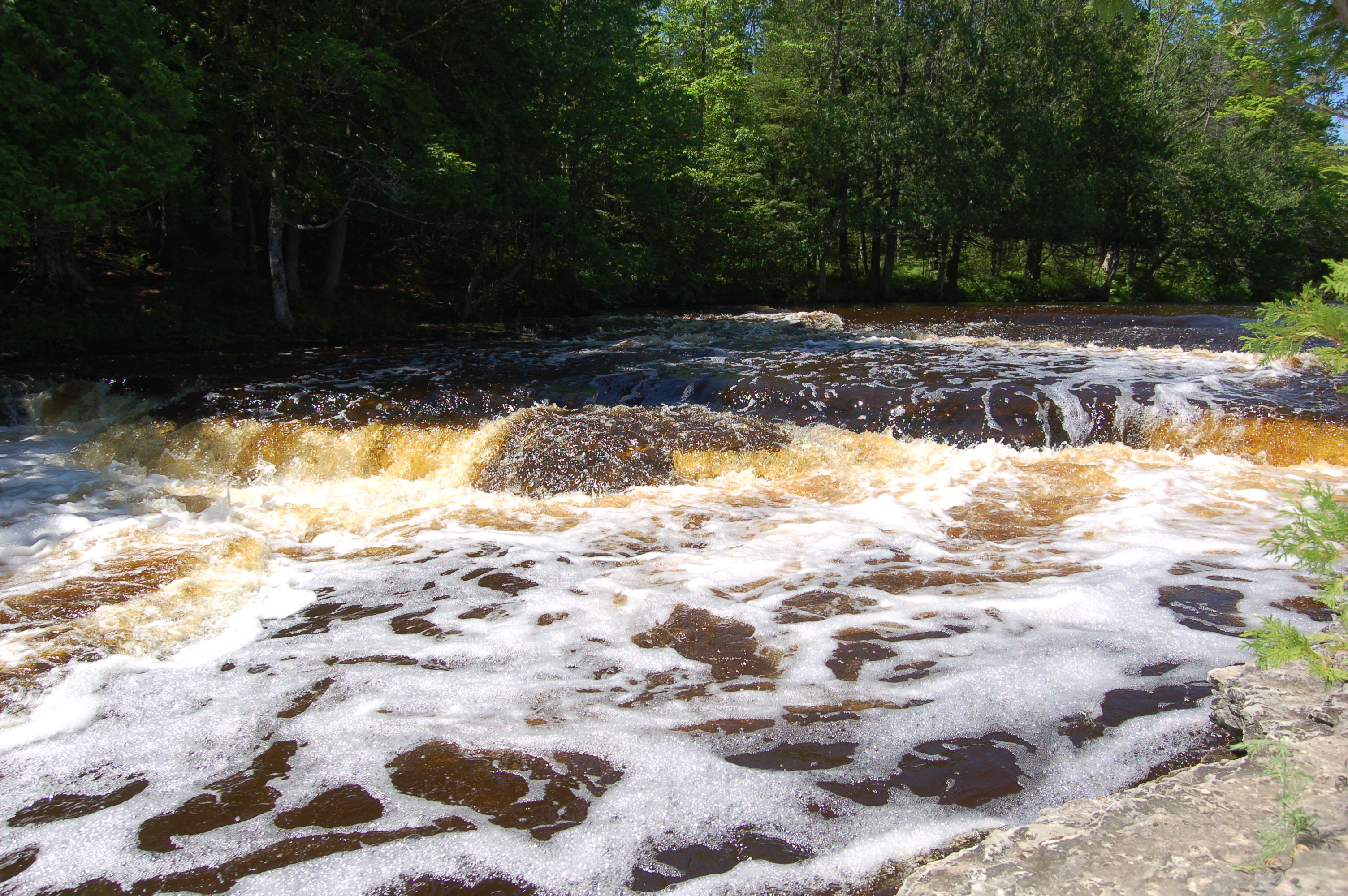
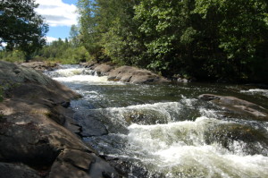
Rapid River Falls – After visiting Haymeadow Falls we return to US-2 and head west to Rapid River. From the junction of US-2 and US-41, head north on US-41 for seven miles. Signs will point the way to Rapid River Park, where there is plenty of parking and a small picnic area and playground. Rapid River Falls is visible from the parking lot, and a sign here informs visitors that “the Rapid River’s limestone bedrock make a shallow and sometimes fast set of waterfalls.” Water levels here can vary a great deal depending on recent rainfall, and the drops are 3-4 feet in height.
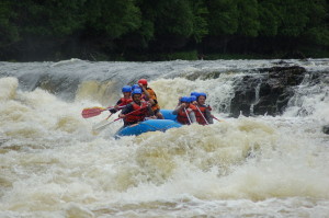
Misicot Falls and Piers Gorge – From Rapid River Falls it is about an hour and a half drive to the next major waterfall, but rest assured it is one that is worth the trip! One of the few waterfalls in Michigan that you can go whitewater rafting over is Misicot Falls, an eight foot drop found in the Menominee River Recreation Area. A great hiking trail follows the river past several sets of rapids to the falls and beyond before returning back for a round-trip of three miles. If you’re interested in whitewater rafting trips check out Kosir’s Rapid Rafts or Wildman Adventure Resort across the border in Wisconsin or Northwoods Adventures in Iron Mountain. From US-2 in Norway, head south on US-8 and follow it for a few mile to Piers Gorge Rd., where signs lead to a parking area and the start of the hiking trail.
Fumee Falls – The next waterfall is one of the easiest to visit on the entire trip. Fumee Falls is located in a roadside park just east of Iron Mountain. There are several drops that combine for a total of 25 feet, and a staircase and trail that lead to the upper section of the falls from the parking lot.
Horserace Rapids – Off the beaten path a few miles south of Crystal Falls is Horserace Rapids, a set of rocky cascades on the Paint River. A short hiking trail leads to this scenic setting, with tall rock bluffs and a wild, untamed river. Shortly after US-2 crosses back into Michigan, head east on County Airport Rd. Follow this road for a little over a mile and a half, then when it forks stay straight on Horserace Rapids Road and follow it to its end at a parking area.
Chicagon Falls – This 10-15 foot drop on Chicagon Creek is one you’re all but guaranteed to have to yourself. Since it has been more than five years since our last visit to Chicagon Falls, we recommend checking with the rangers at Bewabic State Park (four miles west of Crystal Falls) for updated directions (due to the amount of private property in the area) and road conditions (reports from 2017 were that part had washed out).
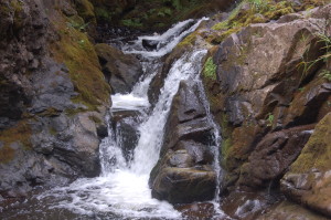
Mex-i-min-e Falls (Burned Dam Falls) – From Crystal Falls it is a 50 minute drive to Watersmeet. When US-2 meets US-45, head north on US-45 for a mile, then take a right onto Old US-2. Follow that for 7 miles to a sign for the Burned Dam Campground. Turn left here on FR-4500 and follow the dirt road about a mile into the campground. Mex-i-min-e Falls (a.k.a. Burned Dam Falls) is a small waterfall that is reached via a short trail in the campground, where a sign explains the origins of its name(s).
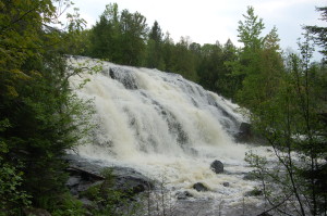
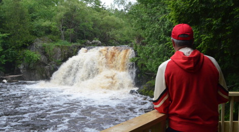
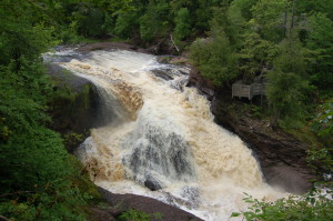
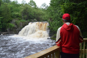
Bond Falls – Continuing north on US-45 from Burned Dam Falls/Watersmeet for about 13 miles brings us to Bond Falls Rd., which after a few miles leads to Bond Falls State Scenic Site and one of the state’s best-know waterfalls. Bond Falls is a stunning 50 foot drop on the middle branch of the Ontonagon River. The river is close to 100 feet wide here and a universally-accessible trail and boardwalk ensure that everyone can enjoy the view.
Kakabika Falls – After heading south back to US-2 and Watersmeet, the voyage west continues for about 15 miles. Head north on CR-527 for less than a mile and look for a parking area for the falls. The Cisco Branch Ontonagon River makes a series of twists and turns as it heads downhill here, forming Kakabika Falls. The water level can vary quite a bit here, we’ve found the best time to visit is in spring or after a heavy rain.
Yondota Falls – It is a short drive to the next waterfall, which is Yondota Falls just north of Marenisco. Turn and follow CR-523 north for a little more than three miles, then look for a parking area just after the road crosses the Presque Isle River. The main plunge here is between five and seven feet in height, and there are numerous cascades above and below the main falls.
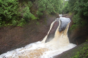
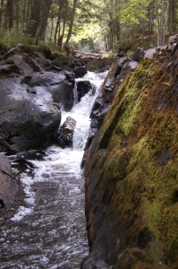
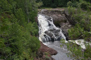
Gabbro Falls – Next up is one of our absolute favorite Upper Peninsula waterfalls. Gabbro Falls features a two-tiered drop into a gorge with a total drop of 40 feet. Getting to the bottom of the gorge would be hard enough and due to a bend in the river the views would be limited, so we found the best spot to view this stunning waterfall is from the top of the gorge. From US-2 head north on Blackjack Rd. (following signs for a ski resort) and follow it for about two miles. The road will cross an old bridge then curve and head sharply uphill – park near the rundown looking buildings here and find the trail on the opposite side of the road.
Powderhorn Falls – The next waterfall is also near a ski area, and the turn off of US-2 for it is impossible to miss. When you see the skier statue on the side of the road, turn and head north on Powderhorn Rd. and follow it for a mile and a half. Just before reaching the Powdermill Resort, pull off on the right side of the road and look for a trail. The trail is short and easy to follow, and a rope is in place to help make the descent down to the river easier. This 15 foot waterfall is worth the effort, and there is another small drop upstream as well.
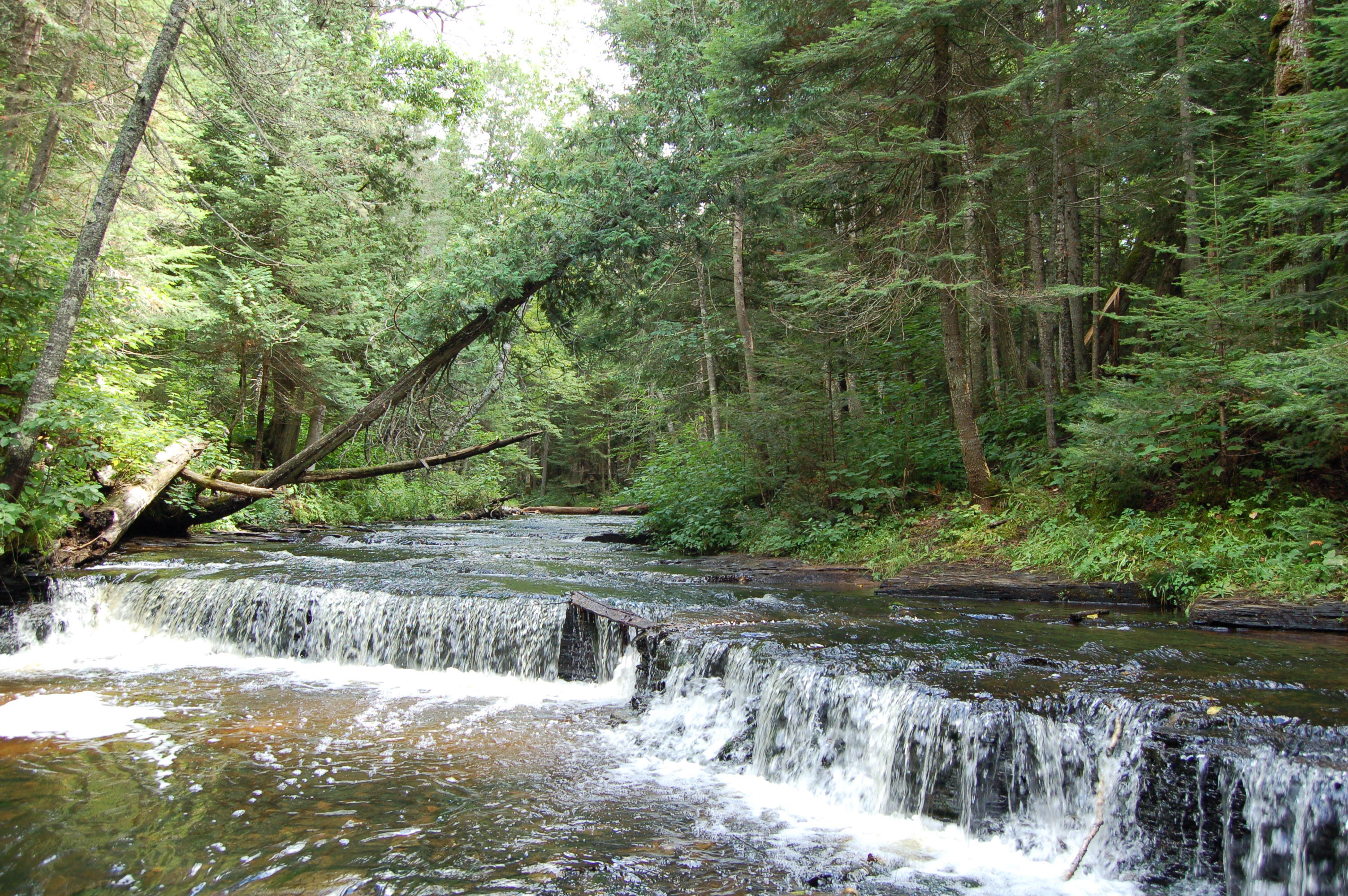
Black River Scenic Byway (5 Waterfalls) – From Powderhorn Falls you can follow Powderhorn Rd. through the ski resort and north to its intersection with Black River Rd. (CR-513) Head north on Black River Rd. and follow it for roughly 10 miles, where the first of several waterfall parking areas is located. The five waterfalls on this scenic byway are each stunning in their own way. From the south to the north you can visit Great Conglomerate Falls (20 feet tall; hiking trail 3/4 mile), Potawatomi Falls (30 feet tall; 1/4 mile hiking trail), Gorge Falls (25 feet tall; 1/4 mile hiking trail), Sandstone Falls (15 feet tall; 1/4 mile hiking trail), and Rainbow Falls (30 feet tall; 1/2 mile hiking trail). After visiting these five stunning waterfalls, make the trip south to Bessemer by following Cr-513/Black River Scenic Byway for 17 miles.
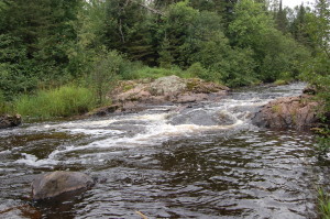
Granite Rapids – This small drop on the Black River is located in Bessemer, where the river makes its way past pink-hued granite rocks. Granite Rapids is a drop of only a few feet, but is located in a quiet and undeveloped area. From US-2 in Bessemer, turn south on Moore St and follow it for a few blocks and its intersection with 1st Ave. Turn right on 1st Avenue and follow the as it curves left as Spring Street. Stay on Spring Street for almost a mile and then turn left on Johnson Road. After 1.5 miles on Johnson turn left on W. Harding Road, which will eventually turn to gravel. After the gravel starts, take the second right/Black River Lane and follow to its end.
Interstate Falls – Recent improvements have made Interstate Falls a must-see on this route, with improved trails leading to a 20-foot drop on the Montreal River. This river forms the border between Michigan and Wisconsin, and access is provided from the Wisconsin side of the river. After US-2 crosses the state line, look for a wooden sign for Interstate Falls and turn north on Center Dr. There is a small parking area and the trail is less than a half mile long.
Saxon Falls – The next set of waterfalls on the Montreal River also require a quick trip into Wisconsin before crossing back into Michigan. Saxon Falls has an upper section with a tall drop, and a lower section with a decent 15-20 foot tall drop – both are robbed of much of their water flow due to a dam on the river. XCel Energy has provided viewing access for this waterfall, be considerate and follow all posted signs and stay on the trails – more info on the path we took during a 2012 visit can be found in our Saxon Falls post. To get here from US-2 in Ironwood, head into Wisconsin, and take County Rd B north to its end, then follow Saxon Falls Flowage Rd. Take the right dirt road at the split, marked for falls access, there is ample parking near the dam. Follow the signs to the trail that will lead to the upper falls (path into the woods) and lower falls (near the powerhouse).
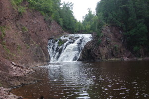
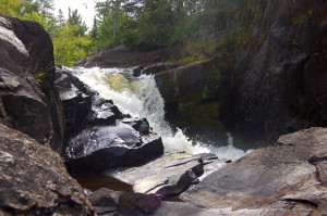
Superior Falls – We end our trip with another impressive cascade on the Montreal River. Superior Falls features a total drop of 90 feet over several sections, with the lower section coming in at roughly 60 feet. Access to the site is provided by XCel Energy and involves a steep downhill hike and a path that follows the river upstream. This is one of our favorite Upper Peninsula waterfalls and worth the extra effort. From Ironwood, take US-2 west into Wisconsin and head north on Hwy. 122. Follow it north for a little over four miles, crossing back into Michigan. Look for a gravel road on the left marked with a sign for the falls shortly after crossing the river.