
A Munising Waterfalls Adventure – 16 Amazing Stops
Waterfalls have long been one of the top tourist draws for Michigan’s Upper Peninsula, and few other places offer the amount of waterfalls that Munising has. With 16 major plunges all located in town or nearby, this is a great town for a waterfall adventure. We’ve put together a list of these 16 waterfalls and provided directions, all while splitting them into categories. Two of these Munising waterfalls can be seen without leaving your car, 5 are reached after short walks that most visitors should be able to handle, 2 are reached after short hikes that are a bit challenging due to steep trails, 2 involve roundtrip hikes of less than two miles, 3 require hikes of a mile or more each way with sometimes challenging terrain, and 2 are best seen from the water. If you’re headed to Pictured Rocks National Lakeshore and the surrounding area, be sure to check out this Munising Waterfalls Adventure!
Alger Falls – can be seen from the car on the side of M-28 directly across from its intersection with M-94. This is a set of several drops on Alger Creek, the tallest of which is close to 15 feet.
Scott Falls – one of the easiest waterfalls to visit in the entire state, Scott Falls is a 10 foot drop over a sandstone cliff into a small pool. It is located on the side of M-28 across from the Rathfoot Rest Area, about 10 miles west of downtown Munising.
Horseshoe Falls – A 20 foot plunge over sandstone cliffs and ledges, Horseshoe Falls is the only privately owned waterfall on this list. It is open to the public for a small admission fee, and the short trail to the falls is wide and well-maintained. The falls are located near the end of Prospect St., just a couple blocks off of M-28 – watch for large signs pointing the way.
Elliot Falls – This small but incredibly scenic plunge is one of the most photographed waterfalls in Pictured Rocks National Lakeshore, and is reached after an easy five minute walk along a well-worn path. Follow signs for the Miners Castle/Miners Beach area off of H-58. Follow the signs towards the beach but when you reach a T intersection, head to the right and the parking for the Lakeshore Trail instead of heading towards the beach.
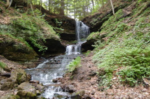
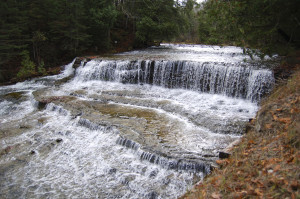
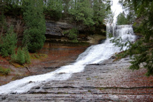
Wagner Falls – This waterfall is part of a Michigan State Scenic Site just south of the city limits, right around the corner from Alger Falls. The hike back to the falls is one almost anyone can handle as it covers less than a half mile of a well-worn trail before ending at a boardwalk observation platform. Wagner Creek drops roughly 20 feet here in its main section. You can find this picturesque waterfall at the intersection of M-28 and M-94.
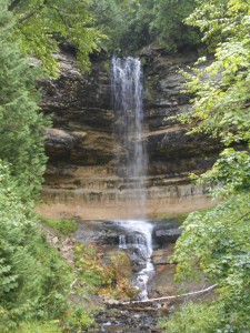
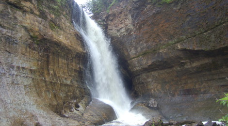
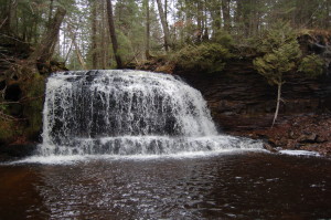
Munising Falls – One of the most visited waterfalls at Pictured Rocks National Lakeshore is Munising Falls, a 50 foot plunge over a sandstone cliff. The short walk back to the falls is on a paved, accessible trail, with viewing platforms that provide three different vantage points. To get to Munising Falls, follow H-58 east of town, then turn left on Washington St. and follow it less than a mile to the Visitor Center parking lot.
Au Train Falls – A dam has robbed this set of falls of some of its glory, but the 40 foot and 10 foot drops here are still worth the short drive from Munising. Both sections here are slow sides over rock ledges, with the width of the river making this an especially beautiful spot. To get to Au Train Falls from Munising head south on M-94 for about 15 miles, then head north on CR-533/Au Train – Forest Lake Rd. After a couple hundred feet there will be a sign for the falls and a dirt road to the right, take that and follow it to the parking areas for the upper falls (first) and lower falls (second).
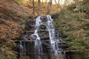
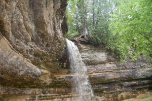
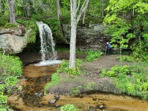
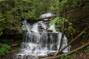
Tannery Falls – These next two falls can be reached from the same parking area and are reached after short (but difficult) hikes down steep trails into a couple of sandstone formations. Also known as Rudy M. Olson Memorial Falls, Tannery Falls makes a 40-foot drop here, and this makes for a great quick trip if you’re looking to et a break from the crowds at Pictured Rocks.
Memorial Falls – Memorial Falls has a similar look and 40-foot drop, but is a little bit less wide than its neighbor. Each of these secluded falls will look better after recent rainfall or spring melt. Head east on H-58 from downtown Munising, and look for Nestor St. on the right as H-58 starts to curve. Park about 500 feet down on Nestor St. by the Michigan Nature Association sign on the right and follow the trail to the falls.
Miners Falls – One of the tallest and most beautiful falls located in Pictured Rocks National Lakeshore, Miners Falls drops about 50 feet over a sandstone ledge. The trail is around a half-mile each way, and is well-worn and wide before it ends with an observation deck. From Munising, take H-58 west until you reach Miners Castle Rd. Around three miles down this road look for the sign for Miners Falls and the road on the right that leads to the parking area.
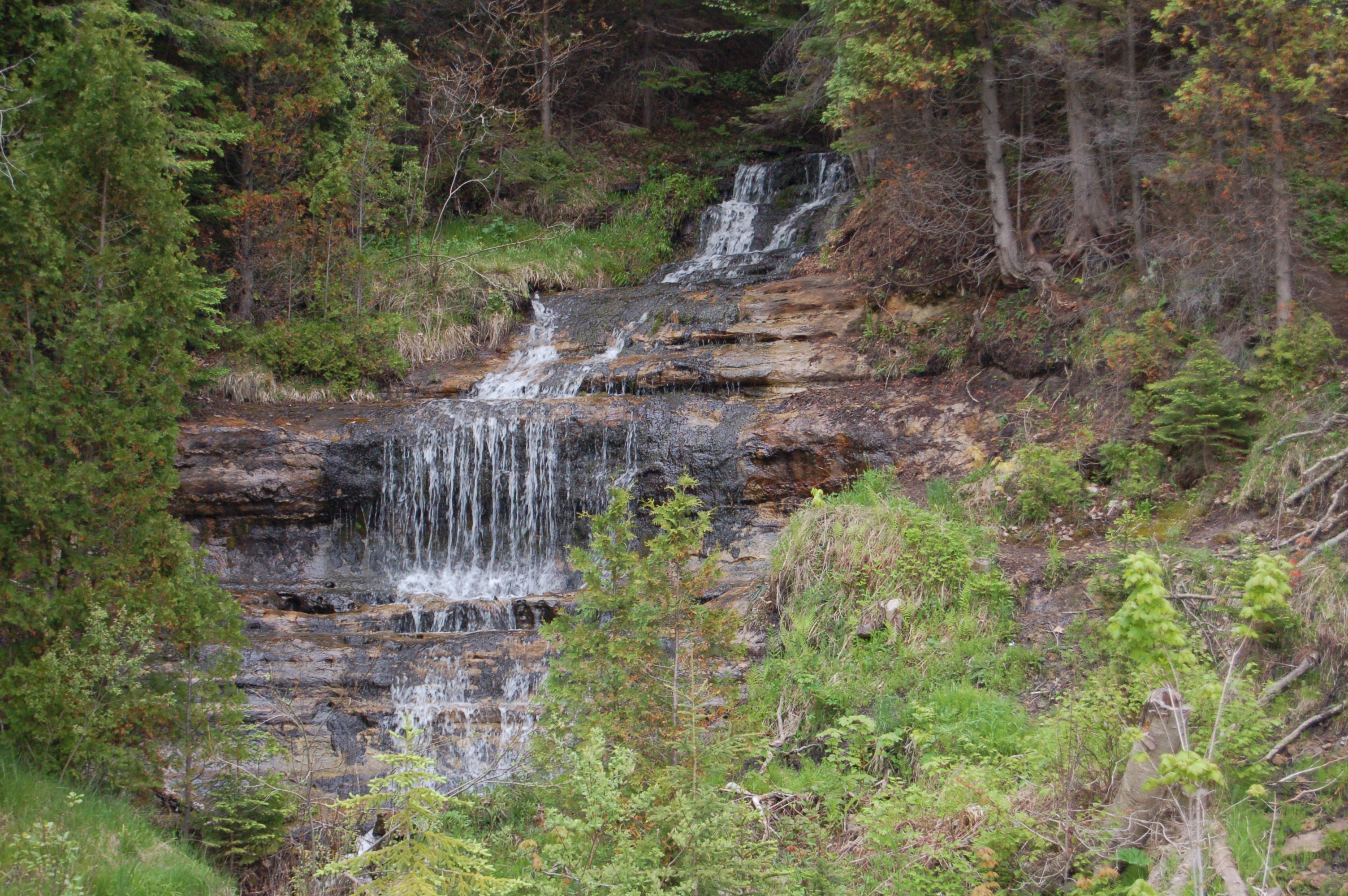
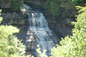
Laughing Whitefish Falls – This State Scenic Site takes visitors on a short hike before arriving at one of the most unique falls in the state. The Laughing Whitefish River makes a 30 foot drop here before fanning out and dropping another 70 feet down into a gorge. The falls looks like a lacy white curtain against the backdrop of the rock face as it makes it descent below the main drop. From M-94 in Sundell and about 30 miles southeast of Marquette/30 miles southwest of Munising, head north on Sundell Rd. for 2 miles, watch for signs to the parking area, down a gravel road on the right. It’s worth the drive and the trail is a well-worn dirt path that covers
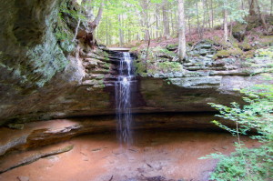
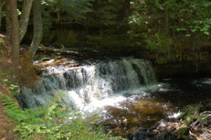
Rock River Falls – The next three falls on this list require a bit more hiking and challenging terrain at times. Rock River Falls drops 15 feet into a small rock canyon, surrounded by wilderness – you will most likely be the only visitor(s) here. From Chatham and the intersection of M-94 and Rock River Rd., head north on Rock River Rd. for four miles. Next, take a left on FR-2276 (also CR-437 and Johnson Lake Tower Rd.) and follow it for almost four miles until FR-2293 (CR-408) forks off to the left. Take that left, and after a half mile watch for a parking area on the left. The area is not well signed, but the trail starts out smooth and wide before getting narrow and winding through the woods. The hike to the falls will be about a mile each way.
Chapel Falls – One of the most rewarding hikes in the Pictured Rocks National Lakeshore is the one that leads to Chapel Falls then continues on to Chapel Rock and Lake Superior. Chapel Falls is a beautiful 60-foot drop that can be viewed from multiple vantage points after a 1.5 mile hike. Take H-58 east of Munising for about 15 miles, then just past Melstrand take Chapel Rd. on the left (signed for Chapel/Mosquito area) and follow it about 5 miles to the parking area.
Mosquito Falls – Reached from the same parking lot as Chapel Falls but on a separate trail, Mosquito Falls is made up of a small five-foot drop and a larger, wider 10-foot drop. This is a more challenging hike than the one to Chapel Falls, and is likewise about 1.5 miles. A trail continues on to Mosquito Beach where there is another set of small falls at Lake Superior. Follow the directions above for Chapel Falls.
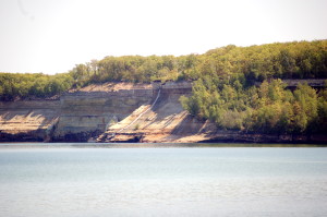
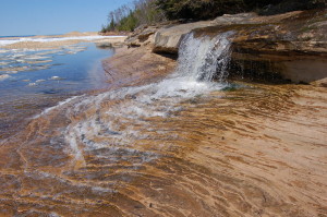
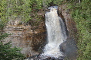
Bridalveil Falls – The tallest waterfall in the national lakeshore is also one of the most infrequent and is best seen in the spring or after a heavy rain. You can view this 140 foot tall slide from Miners Beach or Miners Castle on land, but the best views come from Pictured Rocks Boat Cruises or a kayak trip with one of the local outfitters.
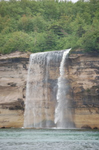
Spray Falls – One of the crown jewels of Pictured Rocks National Lakeshore is Spray Falls, a 70 foot plunge into Lake Superior over a sandstone cliff. The best views come from the water (Pictured Rocks Boat Cruises or an extended kayak trip), but it is possible to hike the Lakeshore Trail for a view as well. Check out our Spray Falls hike photo gallery for more info on the challenging but scenic trip to this amazing waterfall!
Other nearby waterfalls:
Sable Falls is off of H-58, 48 miles to the east in Grand Marais
Whitefish Falls is 32 miles southwest of Munising following M-94 and M-67