
15 Spectacular Waterfalls in Alger County

Michigan’s Upper Peninsula is full of amazing, picturesque waterfalls. With more than 200 total, there’s a good chance you’re never too far from a waterfall on a visit to anywhere in the U.P. No county boasts as many stunning waterfalls packed into a small area the way Alger County does, and these 15 are the ones not to miss. With hundreds of thousands of visitors in the Munising area each year to take in the scenery at Pictured Rocks, various organizations have made almost all of these falls easily accessible to the public. Take a look at the photos, plan a visit, and enjoy some of the best waterfalls in Alger County and possibly all of Michigan!

Rock River Falls – this waterfall is without question the hardest one to get to on this list, but that will only make the experience more rewarding. Rock River Falls drops 15 feet into a small rock canyon, surrounded by wilderness – you will most likely be the only visitor(s) here. From Chatham and the intersection of M-94 and Rock River Rd., head north on Rock River Rd. for four miles. Next, take a left on FR-2276 (also CR-437 and Johnson Lake Tower Rd.) and follow it for almost four miles until FR-2293 (CR-408) forks off to the left. Take that left, and after a half mile watch for a parking area on the left. The area is not well signed, but the trail starts out smooth and wide before getting narrow and winding through the woods. The hike to the falls will be about a mile each way. A detailed map of the Hiawatha National Forest is incredibly helpful here. The area can be swampy, so plan accordingly.

Miners Falls – One of the tallest and most beautiful falls located in Pictured Rocks National Lakeshore, Miners Falls drops about 50 feet over a sandstone ledge. The trail is around a half-mile each way, and is well-worn and wide before it ends with an observation deck. From Munising, take H-58 west until you reach Miners Castle Rd. Around three miles down this road look for the sign for Miners Falls and the road on the right that leads to the parking area.

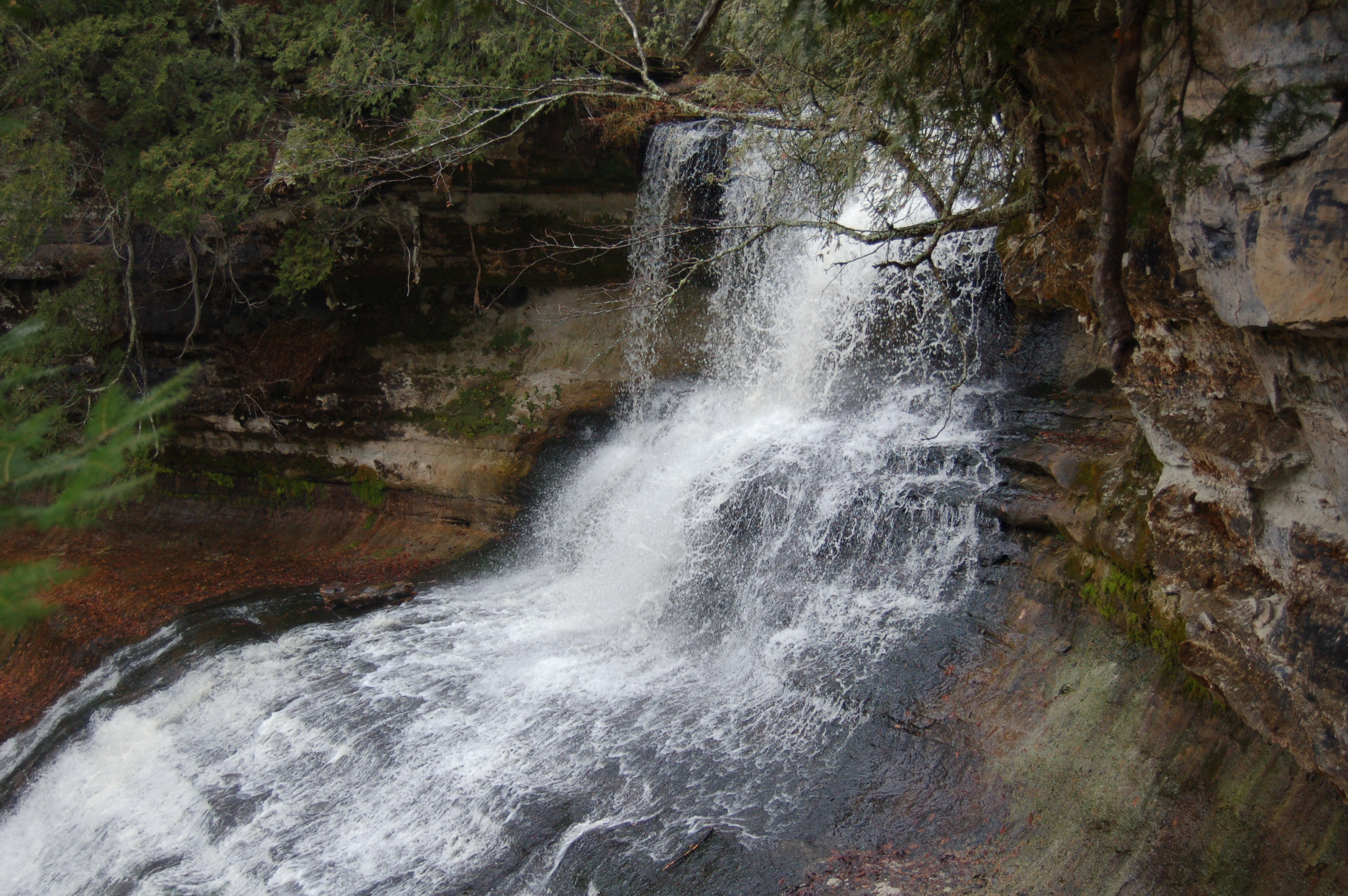
Munising Falls – It will not take much effort to reach Munising Falls, but this waterfall is one of the most popular for visitors to Pictured Rocks National Lakeshore for good reason. Munising Creek plunges 50 feet here, and the sandstone cliff it drops over provides a great backdrop. In Munising, take H-58 west, then take a left on Great Sand Bay Rd. and watch for signs and the parking area for Munising Falls on the right. It is about a 1/8 mile walk to the falls, and there is a staircase to the right that leads up the hill for a better view. While it may look like fun to walk all the way behind the falls there are signs and barriers asking visitors to stay on the main trail due to erosion concerns.

Au Train Falls – A short drive southwest from Munising on M-94 leads to the spectacular Au Train Falls. The flow here is dependent on the dam upriver, but as long as there is some flow this is a beautiful spot where the river widens out to about 30 feet across as it drops over limestone shelves before passing under a bridge and past a powerhouse. Watch for a sign directing you to the road for the falls on the north side of M-94 about 10 miles from Munising.

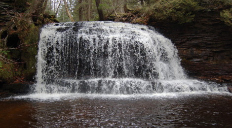
Wagner Falls – A great Michigan State Scenic Site, Wagner Falls should not be missed when in the Munising area. The short hike through shaded woods is a peaceful one, and the sound of rushing water soon adds to this amazing setting. There are three main drops as Wagner Creek makes its way over the rocks, with the largest drop measuring about 6 feet in height. From the intersection of M-28 and M-94, head south on M-94 and look for the parking are almost immediately on the left.

Spray Falls – There are two ways to view Spray Falls – one being from the Pictured Rocks Boat Cruise, the other a hike of at least three miles. Spray Creek plunges 70 feet off a cliff and into Lake Superior here, making for one of the most stunning falls in the state. To hike, start at Little Beaver Lake campground and head for the Lakeshore Trail and head south or start at the Mosquito/Chapel parking area and head to Chapel Beach (3 miles) then hike northeast for another 2 miles to the falls. Pictured Rocks Cruises’ docks are located at 100 City Park Dr. in Munising or check out www.picturedrocks.com for times, prices and details of which trips head all the way out to Spray Falls (not all trips do).

Whitefish Falls – Located near the western border of Alger County, Whitefish Falls is a great spot for a quiet rest by the river for pictures, fishing or a picnic. The largest drop here is only six feet, but the beauty here comes from seeing this river drop multiple times over limestone ledges that span its entire width. Take US-41 north about 4 miles from where it meets with M-67, and look for a gravel road on the left after Diffin Rd. There are multiple paths to the river, all are in good condition and less than 200 feet in length – you should be able to hear or see the falls from any of them. It appears there was once a campground here, as remnants of sites and fire pits still remain.

Sable Falls – At the far eastern end of Pictured Rocks National Lakeshore lies one of its most beautiful waterfalls. Sable Creek drops 75 feet in three sections while flowing towards Lake Superior, and the lacy white of the waterfall and the deep greens of the forest help frame this falls and make it a favorite of photographers. The trail is short and mostly consists of wooden steps down into the gorge. For views of the Grand Sable Dunes, continue on the trail for another quarter mile when it reaches Lake Superior. Take H-58 west about a mile from Grand Marais, and watch for signs leading to the Sable Falls parking area on the right.

Chapel Falls – One of the most rewarding hikes in the Pictured Rocks National Lakeshore is the one that leads to Chapel Falls then continues on to Chapel Rock and Lake Superior. Chapel Falls is a beautiful 60-foot drop that can be viewed from multiple vantage points after a 1.5 mile hike. Take H-58 east of Munising for about 15 miles, then just past Melstrand take Chapel Rd. on the left (signed for Chapel/Mosquito area) and follow it about 5 miles to the parking area.

Mosquito Falls – Reached from the same parking lot as Chapel Falls but on a separate trail, Mosquito Falls is made up of a small five-foot drop and a larger, wider 10-foot drop. This is a more challenging hike than the one to Chapel Falls, and is likewise about 1.5 miles. A trail continues on to Mosquito Beach where there is another set of small falls at Lake Superior. Follow the directions above for Chapel Falls.
Laughing Whitefish Falls – This State Scenic Site takes visitors on a short hike before arriving at one of the most unique falls in the state. The Laughing Whitefish River makes a 30 foot drop here before fanning out and dropping another 70 feet down into a gorge. The falls looks like a lacy white curtain against the backdrop of the rock face as it makes it descent below the main drop. From M-94 in Sundell and about 30 miles southeast of Marquette/30 miles southwest of Munising, head north on Sundell Rd. for 2 miles, watch for signs to the parking area, down a gravel road on the right.

Horseshoe Falls – Horseshoe Falls is a unique waterfall on this list in that it is the only one that is privately owned. There is a small ($6 adults) fee to view this waterfall, but the site also boasts a trout feeding pond, informative signs and many garden gnomes – so there’s a little more here to keep kids busy than at the other falls. The falls itself is formed when the creek makes a 20 foot plunge then spreads out over rock ledges for another 15-20 feet. The water level here remains pretty constant because the creek is spring fed, so when the other falls in the are are underwhelming this one should still impress. From M-28 near the southern city limits of Munising, head east on Prospect St. and follow it about two blocks until it swings left and becomes Bell Ave. Horseshoe Falls is located at 602 Bell Ave.

Scott Falls – One of the easiest falls to access in the entire state, Scott Falls is located on the south side of M-28 east of Au Train. A small creek makes a 10 foot plunge here over a stone ledge, and the water level varies depending on recent rainfall or snowmelt. There is a bit of a cave behind the falls, and plenty of room for a little exploring. The H.J. Rathfoot Roadside Park is right across the road, and provides stunning views of the Lake Superior shoreline.

Tannery Falls – Also known as Rudy M. Olson Memorial Falls, this is one of two relatively unknown falls in the area that drop into horseshoe-shaped rock formations. Tannery Falls makes a 40-foot drop here, and this makes for a great quick trip if you’re looking to et a break from the crowds at Pictured Rocks. Heading east on H-58 from Munising, turn left on Washington Ave. (heading towards Munising Falls) and park on the side of the street where allowed. Walk back across H-58 and look for the staircase that leads up into the nature preserve.

Memorial Falls – Located just around the corner from Tannery Falls, Memorial Falls has a similar look and 40-foot drop, but is a little bit less wide than its neighbor. Both of these secluded falls will look better after recent rainfall or spring melt. Head east on H-58 from downtown Munising, and look for Nestor St. on the right as H-58 starts to curve. Park about 500 feet down on Nestor St. by the Michigan Nature Association sign on the right and follow the trail to the falls.
Wonderful waterfalls.